| 1850 c. |
02221-27
|
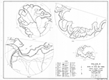
Plat of Marshall, Harrison County |
view

|
| 1915-1925 c |
04167
|
Godwin and Horton Holdings, Township 6 South - Range 6 east, Marshall County, Oklahoma |
Image of map number 04167 is not available.
|
| 1921 |
03048
|
Outline Map of Red River through Tps. 7 and 8 S., Rs 3 and 4 E., Indian Meridian, Oklahoma |
Image of map number 03048 is not available.
|
| 1921 |
03049
|
Outline Map of Red River through Tps. 7 and 8 S., Rs. 5, 6 and 7 E., Indian Meridian, Oklahoma |
Image of map number 03049 is not available.
|
| 1936 |
06663
|
Colorado River Watershed Below Marshall Ford, Area 3715 SQ.MI., Showing Valley Subject to Overflow in Colorado, Wharton and Matagorda Counties, Area 44,000 Acres |
Image of map number 06663 is not available.
|
| 1961 |
05311
|
General Highway Map. Detail of Cities and Towns in Travis County, Texas |
view
|
| 1972 |
05504
|
General Highway Map. Detail of Cities and Towns in Harrison County, Texas. Marshall and vicinity |
view

|
| 1972 |
05677
|
General Highway Map. Detail of Cities and Towns in Travis County, Texas |
view

|
| 1984 |
05888
|
General Highway Map. Detail of Cities and Towns in Harrison County, Texas. Marshall and vicinity |
Image of map number 05888 is not available.
|
| 1984 |
07808
|
Marshall, Texas |
Image of map number 07808 is not available.
|
| 1988 |
07206
|
General Highway Map. Detail of Cities and Towns in Denton County, Texas |
view

|
| 1989 |
07282
|
General Highway Map. Detail of Cities and Towns in Harrison County, Texas. Marshall and vicinity |
Image of map number 07282 is not available.
|
| 1992 |
09215
|
Map of Marshall |
Image of map number 09215 is not available.
|