Texas State Archives Map Collection
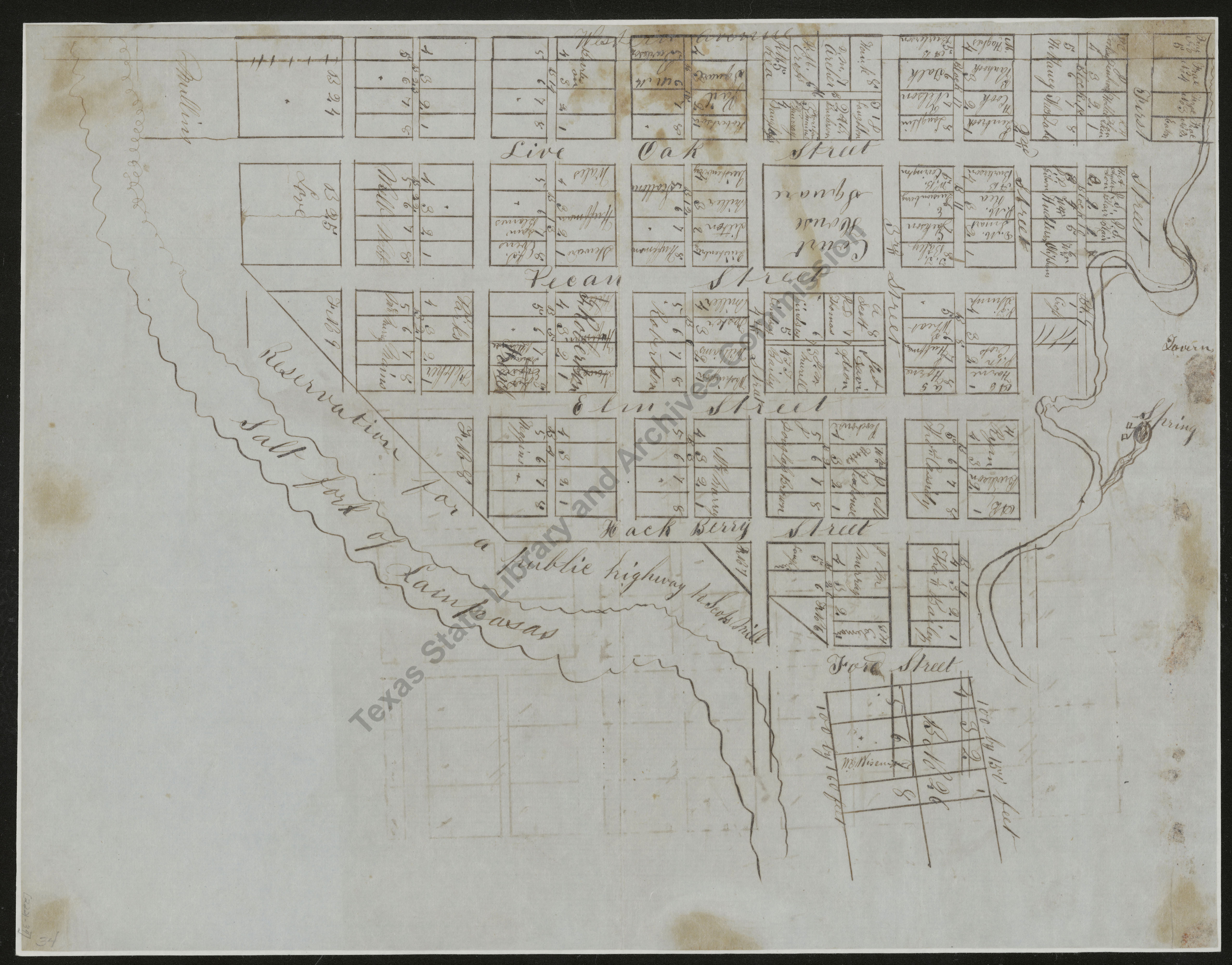
Map of the Business and Industrial Section of Val Verde, Texas
| Date: | 1926 |
| Publisher: | -- None Listed -- |
| Cartographer: |
Bennett, H.E., Civil Eng., Sept. 1, 1926 |
| Scale: | 1 inch = 50 feet |
| Size: | 90 cm x 76 cm |
| Type of Map: | plat |
| Format: | blueprint |
| Language: | English |
| AC Number: | 02221 |
| Photo Media: | -- None Listed -- |
| File Size: | 13.15 MB |
 View Image
 Download Image

 View Image
 Download Image

 View Image
 Download Image

 View Image
 Download Image

 View Image
 Download Image

 View Image
 Download Image

 View Image
 Download Image

 View Image
 Download Image

 View Image
 Download Image

 View Image
 Download Image

 View Image
 Download Image

 View Image
 Download Image

 View Image
 Download Image

 View Image
 Download Image

 View Image
 Download Image

 View Image
 Download Image

 View Image
 Download Image

 View Image
 Download Image

 View Image
 Download Image

 View Image
 Download Image

 View Image
 Download Image

 View Image
 Download Image

 View Image
 Download Image

 View Image
 Download Image

 View Image
 Download Image

 View Image
 Download Image

 View Image
 Download Image

 View Image
 Download Image

 View Image
 Download Image

 View Image
 Download Image

 View Image
 Download Image

 View Image
 Download Image

 View Image
 Download Image

 View Image
 Download Image

 View Image
 Download Image

 View Image
 Download Image

 View Image
 Download Image

 View Image
 Download Image

 View Image
 Download Image

 View Image
 Download Image

 View Image
 Download Image

 View Image
 Download Image

 View Image
 Download Image

 View Image
 Download Image

 View Image
 Download Image

 View Image
 Download Image

 View Image
 Download Image

 View Image
 Download Image

 View Image
 Download Image

 View Image
 Download Image

 View Image
 Download Image

 View Image
 Download Image

 View Image
 Download Image

 View Image
 Download Image

 View Image
 Download Image

 View Image
 Download Image

 View Image
 Download Image

 View Image
 Download Image

 View Image
 Download Image

 View Image
 Download Image

 View Image
 Download Image

 View Image
 Download Image

 View Image
 Download Image

 View Image
 Download Image

 View Image
 Download Image

 View Image
 Download Image

 View Image
 Download Image

 View Image
 Download Image

 View Image
 Download Image

 View Image
 Download Image

 View Image
 Download Image

 View Image
 Download Image

Subjects:
Other Related Maps and Images:
| Date | Map Number | Title | Image |
|---|---|---|---|
| 1850 | 02221-11 | Map of New Braufels and Comaltown |
view

|
| 1850 | 02221-17 | Plan of La Grange |
view

|
| 1850 | 02221-4 | Map of Saluria, Calhoun County, Texas |
view

|
| 1850 | 02221-48 | Map of the Town of Milam in Sabine County, July 11, 1850 |
view

|
| 1850 | 02221-50 | Plan of the town of San Augustine |
view

|
| 1850 | 02221-8 | Plan of the Town of Rusk, Cherokee County |
view

|
| 1850 | 02221-9 | Map of McKinney, the County Seat of Collin County, Texas |
view

|
| 1850 c. | 02221-0 | List of Counties that have furnished Comptroller's Office with Maps... |
view
|
| 1850 c. | 02221-1 | Marion, Angelina County |
view
|
| 1850 c. | 02221-10 | Plat of Columbus, Texas |
view

|
| 1850 c. | 02221-12 | Plat of Gainesville, Texas |
view

|
| 1850 c. | 02221-13 | Plat of Dallas, Texas |
view

|
| 1850 c. | 02221-14 | Map of the Town of Waxahachie, County Seat of the County of Ellis, State of Texas |
view

|
| 1850 c. | 02221-15 | The Town of Stephenville in the County of Erath |
view

|
| 1850 c. | 02221-18 | Map of the Town of Fredericksburg in Gillespie County, Texas |
view

|
| 1850 c. | 02221-19 | Map of the Town of Fredericksburg and Ten Acre Lots |
view

|
| 1850 c. | 02221-2 | Belville , Austin County |
view

|
| 1850 c. | 02221-20 | Map of the Town of Goliad |
view

|
| 1850 c. | 02221-21 | Town of Gonzales and Out Lots |
view

|
| 1850 c. | 02221-22 | Town of Gonzales |
view

|
| 1850 c. | 02221-24 | Plat of the Town of Sherman in Grayson County, Texas |
view

|
| 1850 c. | 02221-27 | Plat of Marshall, Harrison County |
view

|
| 1850 c. | 02221-29 | A Plat of the Town of Texana |
view

|
| 1850 c. | 02221-2a | Plat of the Town Proper of Goliad |
view
|
| 1850 c. | 02221-3 | Map of Meridian, Bosque County |
view
|
The Texas State Archives Map Collection contains original, photo-reproduced, and compiled maps covering the period from the early seventeenth through the late twentieth centuries. For general information about the holdings and descriptive information available, read the map introduction and indexes and types of maps webpages. For our copy policy, view our webpage on preservation, access, and reproductions.
For information on additional maps in our holdings, read Maps in Other TSLAC Collections.